
LDC's Dynamism
Our services are dynamic,
they are flexible and they are modified to meet the diverse needs of our clients. In order to maximize our client’s investments, our team strategically finds the most effective and economically practical solutions for each project.
Clients are encouraged to contact us or request a quote for estimations.
Clients are encouraged to contact us or request a quote for estimations.

Services
Explore or services that can be tailored to meet your needs
Cadastral / Boundary Surveys
Cadastral or Boundary Surveys determine the exact legal limits of a property by analyzing historical records, legal descriptions, and on-site measurements. These surveys establish precise boundary lines, ensuring that land ownership is clearly defined and accurately represented on official plans and titles.
This process is essential for property sales, construction, and resolving disputes. Accurate boundary data helps prevent encroachments and supports proper land development. By providing clarity on legal boundaries, these surveys contribute to the smooth functioning of land management, urban planning, and regulatory compliance.
This process is essential for property sales, construction, and resolving disputes. Accurate boundary data helps prevent encroachments and supports proper land development. By providing clarity on legal boundaries, these surveys contribute to the smooth functioning of land management, urban planning, and regulatory compliance.


TCPD Approvals
Town and Country Planning Development Approvals ensure that land use and construction projects align with local zoning regulations and long-term planning objectives. These approvals help manage growth, protect the environment, and promote orderly development within urban and rural communities.
Applications typically involve site analysis, layout design, and compliance with planning policies. Approval is necessary before initiating subdivision, building, or land-use changes. This process supports sustainable development by balancing private interests with public needs, infrastructure capacity, and environmental protection.
Applications typically involve site analysis, layout design, and compliance with planning policies. Approval is necessary before initiating subdivision, building, or land-use changes. This process supports sustainable development by balancing private interests with public needs, infrastructure capacity, and environmental protection.
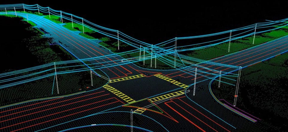
Engineering Surveys
Engineering Surveys provide critical data for the design and construction of infrastructure projects such as roads, bridges, and buildings. These surveys capture precise measurements of terrain, existing features, and elevation, forming the foundation for accurate planning, design, and alignment of engineering works.
Detailed topographic information, control points, and site conditions are documented to guide construction activities and ensure structural integrity. Engineering Surveys support efficient project execution, minimize errors, and help maintain compliance with engineering standards and regulatory requirements throughout the development process.
Detailed topographic information, control points, and site conditions are documented to guide construction activities and ensure structural integrity. Engineering Surveys support efficient project execution, minimize errors, and help maintain compliance with engineering standards and regulatory requirements throughout the development process.


Topographic and As-Built Surveys
Topographic Surveys capture detailed information about the natural and man-made features of a site, including contours, elevations, vegetation, and existing structures. This data is essential for planning, design, and decision-making in construction, landscaping, and infrastructure development projects.
As-Built Surveys document the exact locations and specifications of completed construction work. These surveys verify that projects have been built according to approved plans and are crucial for final inspections, project handovers, and future maintenance or modifications to the site.
As-Built Surveys document the exact locations and specifications of completed construction work. These surveys verify that projects have been built according to approved plans and are crucial for final inspections, project handovers, and future maintenance or modifications to the site.
Photogrammetric Mapping
Photogrammetric Mapping involves capturing and interpreting aerial or satellite images to create accurate maps and 3D models of the Earth's surface. This method efficiently covers large areas and is widely used in planning, resource management, and environmental monitoring.
The process converts photographic data into measurable spatial information, identifying topographic features, land use patterns, and infrastructure. Photogrammetry supports detailed analysis and decision-making in urban development, transportation planning, and disaster response, offering a cost-effective and precise alternative to traditional ground-based mapping techniques.
The process converts photographic data into measurable spatial information, identifying topographic features, land use patterns, and infrastructure. Photogrammetry supports detailed analysis and decision-making in urban development, transportation planning, and disaster response, offering a cost-effective and precise alternative to traditional ground-based mapping techniques.

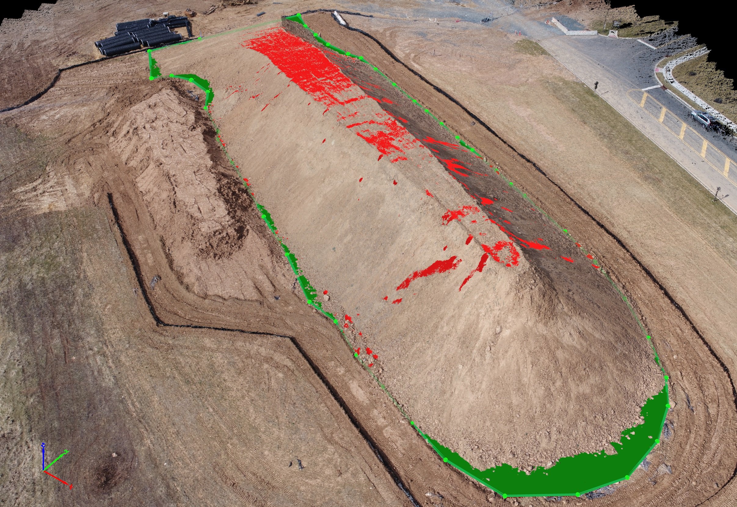
Volumetric and Stockpile Surveys
Volumetric and Stockpile Surveys measure and calculate the quantity of materials such as soil, gravel, or minerals stored in piles or excavated from sites. These surveys provide accurate volume data essential for inventory management, billing, and project planning in construction and mining operations.
By using precise measurement techniques and 3D surface modeling, changes in volume over time can be tracked and compared. This ensures efficient material usage, minimizes waste, and supports financial accountability, helping projects stay on budget and within regulatory compliance.
By using precise measurement techniques and 3D surface modeling, changes in volume over time can be tracked and compared. This ensures efficient material usage, minimizes waste, and supports financial accountability, helping projects stay on budget and within regulatory compliance.
Condominium Surveys
Condominium Surveys define the spatial boundaries of individual units, shared areas, and the overall property within a multi-unit development. These surveys are essential for legal registration, ensuring each unit is accurately described and can be individually owned, sold, or mortgaged.
The survey includes detailed floor plans, elevation data, and common element layouts. This information supports proper management of shared spaces, resolves ownership disputes, and ensures compliance with building codes and condominium regulations throughout the life of the development.
The survey includes detailed floor plans, elevation data, and common element layouts. This information supports proper management of shared spaces, resolves ownership disputes, and ensures compliance with building codes and condominium regulations throughout the life of the development.

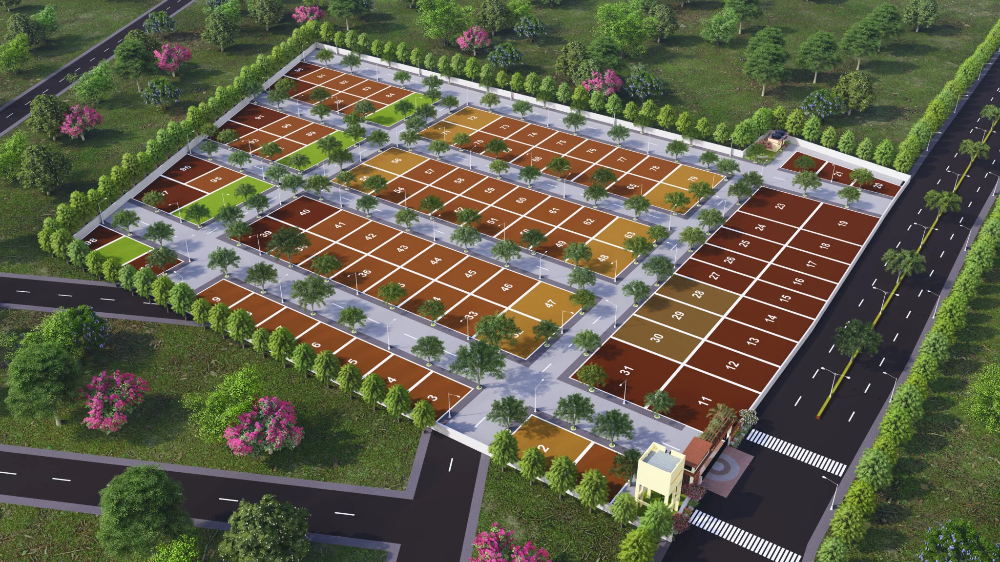
Subdivision Surveys
Subdivision Surveys involve dividing a larger parcel of land into smaller lots for residential, commercial, or industrial use. These surveys establish new property boundaries, roadways, easements, and utility corridors, forming the legal framework for land development and ownership transfer.
Accurate plans are prepared for submission to planning authorities, ensuring compliance with zoning laws, development standards, and infrastructure requirements. Subdivision Surveys support orderly urban growth, facilitate land sales, and help create functional, well-organized communities with proper access, drainage, and public services.
Accurate plans are prepared for submission to planning authorities, ensuring compliance with zoning laws, development standards, and infrastructure requirements. Subdivision Surveys support orderly urban growth, facilitate land sales, and help create functional, well-organized communities with proper access, drainage, and public services.
Draughting and Mapping Services
Draughting and Mapping Services involve the preparation of detailed plans, drawings, and maps that represent spatial data collected during surveys. These documents are essential for visualizing land features, infrastructure, and boundaries in formats suitable for planning, design, and legal documentation.
Using specialized software and precision techniques, clear and accurate representations are produced for various applications, including development proposals, title registration, and engineering design. These services ensure that spatial information is effectively communicated to stakeholders, supporting informed decision-making and efficient project execution.
Using specialized software and precision techniques, clear and accurate representations are produced for various applications, including development proposals, title registration, and engineering design. These services ensure that spatial information is effectively communicated to stakeholders, supporting informed decision-making and efficient project execution.

Pipeline Surveys
Subdivision Surveys involve dividing a larger parcel of land into smaller lots for residential, commercial, or industrial use. These surveys establish new property boundaries, roadways, easements, and utility corridors, forming the legal framework for land development and ownership transfer.
Accurate plans are prepared for submission to planning authorities, ensuring compliance with zoning laws, development standards, and infrastructure requirements. Subdivision Surveys support orderly urban growth, facilitate land sales, and help create functional, well-organized communities with proper access, drainage, and public services.
Accurate plans are prepared for submission to planning authorities, ensuring compliance with zoning laws, development standards, and infrastructure requirements. Subdivision Surveys support orderly urban growth, facilitate land sales, and help create functional, well-organized communities with proper access, drainage, and public services.